
Overview
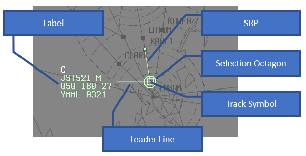
A track is a graphical representation of an aircraft position, provides essential information about the aircraft and facilitates recording of new information via mouse interaction.
Tracks may consist of a combination of the following features:
- track symbol
- leader line
- track label
- short route probe
- velocity vector
- history trails
Track States
Tracks can be presented in a number of states. Current state affects the type of track and label shown, and it’s colour. Strips are also coloured based on the associated track state.
Track state is decided based on combination of flight plan state and the flights relevance to your selected Sectors.
| State | Meaning | Track Colour (Default Profile) |
|---|---|---|
| Jurisdiction | Controlled by you | |
| Announced | Soon to affect your sectors (FDR not departed yet or inbound from adjacent airspace) | |
| Handover In | Handoff proposed to you | (flashing) |
| Handover Out | Handoff proposed by you | |
| Post Jurisdiction | Handover Out accepted | (flashing) |
| Preactive | FDR has not been activated (strip state only) | |
| Ghost Jurisdiction | Controlled by another controller that is also one of your selected sectors (Shadow Mode) | |
| Non Jurisdiction | All other tracks |
When the invididual quick-look (IQL) tool is used on a track, the colour of the track changes:
| State | Eurocat Australia Colour (Default Profile) |
|---|---|
| Jurisdiction | |
| Others |
IQL disables filters for an individual track.
The brightness of the track colours can be adjusted in the Display Settings window.
Track Symbols
The track symbol indicates the position of the aircraft and the source of that information.
The track symbol position is based on the best source of information available to vatSys. The order of precedence is as follows:
- radar (SSR)
- ADS-B
- flight plan predicted position
The shape of the track symbol indicates the source of position information and special SSR codes.
| Tracks | Symbols (Default Profile) | ||
|---|---|---|---|
| Primary Radar |  | Secondary Radar |  |
| Radar extrapolated position (coast) |  | SSR code 0001 |  |
| SSR code 0100 |  | SSR code 1200 |  |
| SSR code 2000 |  | ADS-B |  |
| ADS-B extrapolated position (coast) |  | Cancelled |  |
| Flight plan |  |
Where a primary return is detected with a secondary return, a combined track is presented.

When an aircraft activates the IDENT feature of the transponder, the track symbol flashes cyan.

The “radar track cancelled” symbol is displayed when a track is no longer detected by radar. The history trails are removed one-by-one on each screen update and the cancelled symbol is removed after the history trails.
Labels
Track labels are displayed for all tracks, except filtered tracks and primary tracks. Track labels are connected to their respective track symbols by a leader line.
The position of track labels relative to their track symbols can be adjusted by RIGHT CLICK on the track symbol or level field in the track label. The draw order of track labels track labels must be manually adjusted so that they do not overlap and become obscured.
The type of label presented is determined by the available information for the track, and individual and global track display settings.
Note: All tables and diagrams below refer only to the default profile, Eurocat Australia, though label items may be used in other profiles.
| Label Type | Tracks | Items (Default Profile) | ||||||||||||||||||||||||||||||||||||||||||
|---|---|---|---|---|---|---|---|---|---|---|---|---|---|---|---|---|---|---|---|---|---|---|---|---|---|---|---|---|---|---|---|---|---|---|---|---|---|---|---|---|---|---|---|---|
| Limited | Uncoupled Radar or ADS-B tracks |
| ||||||||||||||||||||||||||||||||||||||||||
| Quick-Tag | Uncoupled Radar or ADS-B tracks with quick tag |
| ||||||||||||||||||||||||||||||||||||||||||
| Normal | Coupled or Flight Plan tracks |
| ||||||||||||||||||||||||||||||||||||||||||
| Extended | Coupled or Flight Plan tracks with Extended labels toggled |
| ||||||||||||||||||||||||||||||||||||||||||
| Extended - Shared | Coupled or Flight Plan tracks with Extended and Shared labels toggled |
|
| Label Fields | Content | Action |
|---|---|---|
CPDLCMSG | Current unacknowledged CPDLC message | LEFT CLICK to open CPDLC Menu. MIDDLE CLICK to toggle display. RIGHT CLICK to open CPDLC Editor Window. |
C | Togglable Coordination Prompt | MIDDLE CLICK to toggle display of C prompt. |
RWY | Arrival or Departure Runway | LEFT CLICK to open Runway Menu |
EMG | EMG (code 7700) or RAD (code 7600) | MIDDLE CLICK to acknowledge. |
WARN | Highest priority current alert abbreviation See alerts | MIDDLE CLICK to acknowledge. |
CALLSIGN | Callsign or SSR code | LEFT CLICK to open Callsign menu. MIDDLE CLICK to toggle extended label display. RIGHT CLICK to open SAR Window. |
+ | CPDLC status indicator ( +, - or blank) | LEFT CLICK to open CPDLC Editor Window. MIDDLE CLICK to toggle CPDLCMSG display. |
W | Wake turbulance category | |
* | Important information (STS/) contained in FDR | LEFT CLICK to open Flight Plan Window. |
LVL | Mode C level or Pilot Reported LEVEL | LEFT CLICK to enter Pilot Reported Level (FP tracks only). RIGHT CLICK to position label. |
> | Vertical direction indicator (positive ^, negative v, cruise >) | |
CFL | Cleared flight level, colour toggleable | LEFT CLICK to open CFL Window. MIDDLE CLICK to toggle CFL colour. |
F | Flight rule abbreviation | |
GS | 2 digit rounded Groundspeed | |
b | ADS-B not flight planned indicator | |
WXL/WXR | Weather deviation clearance (local only) | LEFT CLICK to open Weather Diversion Menu. |
CLL | Lower bound of a block Cleared Flight Level | LEFT CLICK to open CFL Window. MIDDLE CLICK to toggle CFL colour. |
ADES | Destination | |
ATYPE | Aircraft Type | |
N | Performance Based Navigation capability ( A RNP2 and RNP10/4, 2 RNP2, 4 RNP4, 5 RNAV5, T RNP10, Z none) | |
NEXT | Next route waypoint | |
NEXT+1 | Next route waypoint + 1 | |
OPDATA | Label Operational Data (scratchpad) | LEFT CLICK to edit Label Op Data. RIGHT CLICK to toggle display of WX/BLOCK label line. |
Alerts
Alerts trigger an audible and visual warning on a track label. High priority alerts are shown with a solid red background in addition to yellow text.
| Alert | Label Abbreviation | Priority | Default Criteria |
|---|---|---|---|
| Cleared Level Adherence Monitoring | CLAM | 3 | CFL is not None, VSA or 000 and;Maintaining:
Change of Level:
|
| Danger Area Infringement Warning | DAIW | 1 | Radar trajectory will enter dangerous volume in 60 seconds |
| Estimated Time Over | ETO | 4 | (Not yet implemented) Pilot estimated time over waypoint disagrees with system calculated time by more than 180 seconds |
| Missed Position Report | MPR | 4 | 180 seconds after waypoint ETO when MPR is armed |
| Minimum Safe Altitude Warning | MSAW | 1 | CFL is not None, VSA or 000 and radar trajectory will be within 600FT of projected obstacle height in 60 seconds |
| Medium Term Conflict Alert | MTCA | 3 | (Not yet implemented) |
| Route Adherence Monitoring | RAM | 3 | Radar track is outside of:
|
| Search and Rescue | SAR | 3 | SAR Timer has expired. SAR Timer is automatically set to ETA+10 minutes when no arrival runway is selected |
| Short Term Conflict Alert | STCA | 1 | Radar trajectories of two or more radar tracks will be less than: Level (bound by CFL)
Distance
In the next 60 seconds for TMA volumes and 90 seconds for Enroute volumes, and the trajectory is not within defined airport STCA inhibition areas. |