Overview
This page will walk you through the tools available for interacting with the vatSys display and aircraft Tracks. Tools may be accessed through the Tools menu, Callsign menu or Keyboard commands. Tool behaviour may change based on the type (or lack) of aircraft track selected.
| Abbreviation | Accessed Via |
|---|---|
| TM | Tools Menu |
| KC | Keyboard Command |
| CM | Callsign Menu |
Key commands may be viewed here.
Velocity Vectors
TM
Velocity Vectors display where a Radar/ADSB track is projected to be after a certain time based on derived ground speed and ground track. This will show as a straight line as per the selected range in time for all surveillance tracks, with minute intervals marked along the line.
| Velocity Vector | |
|---|---|
 |
Range - A list of options in minutes with the default being 2 |
Short Route Probe
TM
Short Route Probe function projects a line from an aircraft track along the flight plan route. To be eligible for SRP, the track must be a flight plan track or a coupled radar/ADSB. SRP can be displayed either as a time value, or a distance value. You can turn this function on by selecting an individual aircraft and pressing the SRP assigned key (default key = multiply). To display globally (all aircraft), click “Default On” in the SRP drop down options.
| Short Route Probe | |
|---|---|
  |
Time - A list of options in minutes with the default being 5 |
  |
Distance - A list of options in nautical miles |
 |
Default On- Enable SRP globally (all aircraft) |
History Trails
TM
History Trails display past radar/ADSB updates for each track. Up to 9 past updates may be selected.
| History Trails | |
|---|---|
 |
Range - A list of options up to 9 past position updates. Default setting is 5 |
FPASD
TM
Flight Plan Air Situation Display toggles the display of Flight Plan tracks on ASDs. Default on.
If deselected, only radar / ADS-B tracks are presented. Strips are unchanged.
Extended Labels
TM
Extended labels toggles the global display of the extended label line, if defined, in labels when the track state is at least Announced.
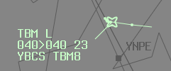
Extended labels may also be toggled invidivually using the label clickspot.
Shared Labels
TM
Shared labels toggles the display of timeshare label data lines. Default off.
When selected, Air and Ground track labels that contain timeshared lines will display alternating information every 4 display updates (2.4 seconds).
SSR Callsigns
TM
SSR Callsigns displays the SSR code being transmitted by the aircraft instead of their callsign. When enabled this displays globally (all aircraft labels).
Disable Filters
TM, KC
Disables all current filters (level, airports).
Filters
TM
Filters hide aircraft labels of non-concerned tracks based on a specified altitude range in order to reduce label clutter.
| Filters | |
|---|---|
 |
Lower Level - 3 digit selection for lowest visible level |
 |
Upper level - 3 digit selection for highest visible level |
Inhibited List
TM
Inhibited list displays flight plans that have been inhibited. Selection of a flight plan from this list will uninhibit that flight plan.
Graphic Reroute
KC, CM
Graphic Reroute is an interactive function that allows the cleared route to be drawn on the ASD.
The reroute may commence from the aircraft Track or any existing downstream flight planned waypoint. Subsequent LEFT CLICK will add waypoints to the reroute, or Lat/Long positions if the cursor location is not near to a waypoint. Reroute will complete without confirmation on joining either a downstream waypoint or the Destination airport.
MIDDLE CLICK will cancel an in progress reroute with no change to route.
User Position Report (UPR)
KC
User Position Report updates route estimates for uncoupled FDR’s to position the Flight Plan Track at the mouse cursors location. Cursor must be positioned over the desired point of the route (forwards or backwards) before executing the key command. There is a 5 second timeout after the use of this function to reduce the number of synchronising messages being sent over the network.
Quick Tag
TM, CM
Quick Tag provides the ability to label un-coupled radar/ADSB tracks locally to your client only. Limited label functions are then possible without any flight plan interaction. Adding a Quick Tag will allocate a discrete SSR code enabling re-coupling should the aircraft leave surveillance coverage. After 5 minutes of not being coupled, the Quick Tag is automatically removed.
| Quick Tag | |
|---|---|
 |
Add or Remove - adjusts the label as selected |
Bearing and Range Line
TM, KC
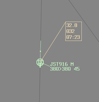
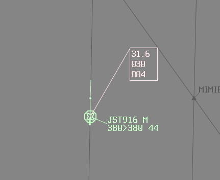
Bearing and Range tool displays a bearing in degrees (Magnetic only if defined for current Position), range in Metres for Ground Situation Displays otherwise Nautical Miles, and a time to go in minutes when anchored on a track. Time to go is given as a 4 digit UTC time when both ends are anchored.
| Bearing and Range | |
|---|---|
 |
 |
Conflict Area
TM, KC
Conflict Area Tool determines the area that two flight plan routes are in lateral conflict. Select one track and click on the other. The drop down values are defined in the current profile and correspond to the required minimum lateral distance between the two routes. On successful calculation of a conflict area, the area with entry and exit times for both aircraft is displayed.
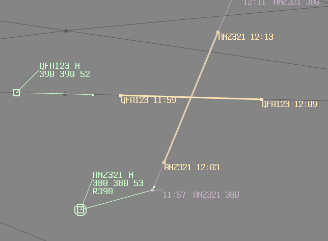
To clear a displayed conflict area, MIDDLE CLICK either callsign time label at the entry/exit point.
Closest Approach
TM, KC
Closest Approach tool displays the point at which two flight plan trajectories are closest. Select one track and click the other to display closest approach trajectory.
Note: Whilst surveillance data is used to update flight plan trajectories, this tool is not using current radar/ADSB data.
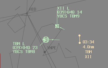
To clear a displayed closest approach point, MIDDLE CLICK the text label.
Disable GRIB Winds
TM, KC
Disable GRIB Winds disables the use of GRIB winds and temperatures for individual flight plans. A track must be selected for this to feature to be available.
GRIB Winds may be disabled globally in the Settings menu.
SELCAL
TM
SELCAL (selective calling) opens the SELCAL Window, for the sending of HF/VHF SELCAL tones. If a track is selected with SELCAL code present in their flight plan, the Window will be initialised with this value.
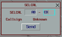
Manual code entry will attempt to resolve callsign from the current list of flight plans.
Send Contact Me
TM, KC
Contact Me sends an automated private message directly to a pilot requesting contact on one of your selected frequencies.

A key command also exists for this function.
Request Break
TM
Request Break toggles the selection of the break indicator to surrounding controllers.

Show Vis Centers
TM
Show Vis Centers displays the currently set network Visibility points. Display will self time out and cannot be manually removed.
Add Text Area
TM, KC
Add Text Area creates a new text area on the situation display, local to your client. Complete the text field and key Enter to finish.
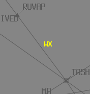
RIGHT CLICK and drag to move the text to another location. MIDDLE CLICK to delete.
